|
|
|||||||||||
|
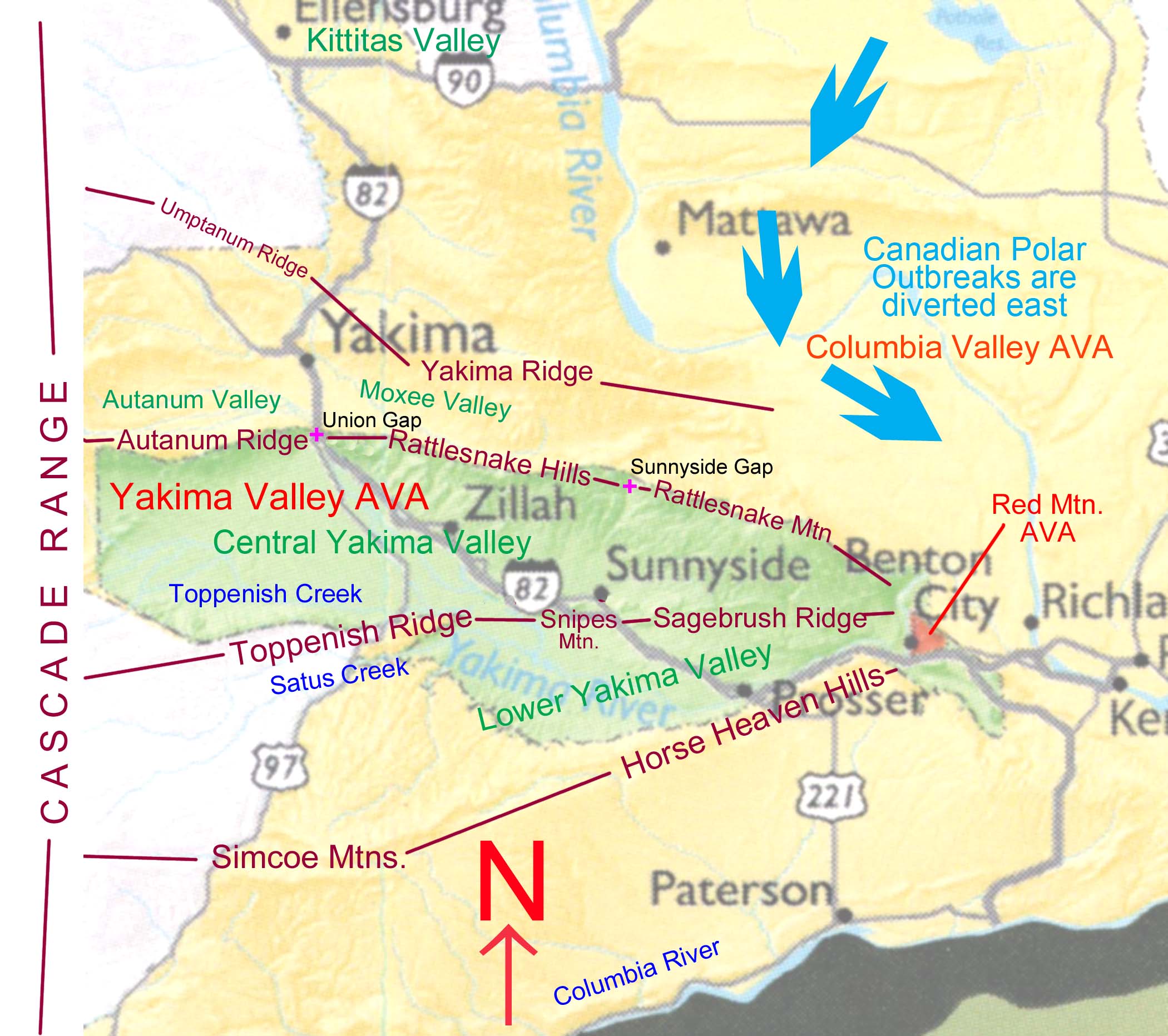
The Cascade Range, running north to south, divides Eastern Washington from Western Washington. The altitude of the intervening Cascade Range determines the amount of moderating temperature influence and rainfall from the Pacific Ocean that Eastern Washington gets. South Central Washington State is made up of a series of east-west mountain ranges running from the Cascade Range to the Columbia River. These ranges in turn define five valleys that have differing characteristics depending on the Cascade Range to the west, as wind generally blows from the west to the east following each valley and giving it a unique climate. The first valley starting from the south is that of the Columbia River (typical elevation of the valley floor is 266 ft.). Since the Columbia River Gorge dissects the Cascade Range, air from the Pacific Ocean is funneled between Mt. Adams. (12,277 ft.) and Mt Hood in Oregon (11,239). This valley is bounded on the north by Simcoe Mountains (highest point 5,823 ft.) and the Horse Heaven Hills. This is Eastern Washington’s most moderate climate. It gets a cooling effect from the ocean in the summer and a warming effect in the winter. The second valley (see map 1) is headed by Satus Creek on the west and continues to the Red Mountain AVA on the east (typical elevation on the valley floor is 650 ft.). This is locally called the Lower Yakima Valley. The Simcoe Mountains and Horse Heaven Hills form this valley on the south and Toppenish Ridge (highest point 3280 ft), Snipes Mountain, Grandview Butte, and Sagebrush Ridge on the north. The Cascade Range is typically about 3000 ft high and air spills into this valley from the Columbia Gorge south of Mt. Adams, making this the second most moderate valley in south central Washington. Moderating winds from the Columbia River also spill over the Horse Heaven Hills, which are only about 1600 ft. high. The third valley is headed by Toppenish Creek on the west and continues east all the way to the Red Mountain AVA (typical elevation on the valley floor is 770 ft.). This is locally called the Central Yakima Valley. It is bounded on the south by Toppenish Ridge, Snipes Mountain, Grandview Butte, and Sagebrush Ridge. It is bounded on the north by Autanum Ridge, Rattlesnake Hills, and Rattlesnake Mountain (highest point 3524 ft.). This valley is commonly not recognized as a separate valley since the gap between Toppenish Ridge and Snipes Mountain through which the Yakima River flows is about two miles wide and is therefore not named as a gap, as are Union Gap and Selah Gap. The Cascade Range to the west is typically 4000 ft. to 5000 ft. cutting off much of the moderating influence of the Pacific Ocean. Some southwest winds can enter the valley from a low ridge between Toppenish Mountain and Mt. Adams. Summer temperatures are typically warmer here than in the LowerYakima River Valley. There are approximately 2000 acres of wine grapes planted in the CentralYakima River Valley between the foothills of the Cascade Range and the Yakima County line. The fourth valley (see map 1) is headed by Autanum Creek and the Naches River and continues east to the Moxee Valley (typical elevation on the valley floor is over 1000 ft.). It is bounded on the south by Autanum Ridge and the Rattlesnake Hills. It is bounded on the north by Umptanum Ridge and Yakima Ridge. The Cascade Range to the west rises to over 6000 ft. This valley is commonly called the Upper Yakima Valley and is at a higher elevation and although still moderate, has characteristics that are more akin to a mountain climate. Summers are warm, but not nearly as hot as in the valleys to the south. This is home to the Naches Heights AVA. The fifth valley (the fourth valley of the Yakima River) is the Kittitas Valley. It is not significant to the discussion here. Wine grapes are not commercially planted in the Kittitas Valley and probably will not be in the near future. Elevation and Physical FeaturesThe Rattlesnake Hills are characterized by an east-west ridge top with highly dissected canyons, terraces, and ridges running southward off the main ridge toward the Yakima River. Vineyards are typically located on ridges and terraces and in areas with good air drainage to avoid late spring and early fall frost and winter kill. Elevation is one of the chief definitions of the Rattlesnake Hills. Vineyards in this area are the highest in the state. The minimum elevation in the Rattlesnake Hills is 850 feet and the highest vineyard on Elephant Mountain tops out at 1600 feet. Growing vinifera below 850 feet elevation in this region has proven to be difficult to impossible due to spring and fall frosts and winter kill, alkali soils, and/or a high water table. If water is available, it is considered possible to grow vinifera at elevations up to 2000 feet in the Rattlesnake Hills. Webmaster Rattlesnake Wine © 2024 All rights reserved
|
||||||||||